


FIRST BRIDGE PROJECT
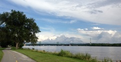
A Gateway to Downtown. The First Bridge project aims to recreate a single 254-foot span of the first railroad bridge to cross the Mississippi River in 1856 and open a safe recreation trail crossing point and key connection to existing riverfront bike and pedestrian trails and parks. First Bridge will provide a much-needed safe crossing for pedestrians and bicyclists over four-lane East River Drive and the Canadian Pacific Railroad line, in an area where the crossing risk is high. US-67 or River Drive sees daily traffic of as many as 20,000 vehicles and several trains traverse the CP Rail line each day. There is currently no safe public access point to the Mississippi River Trail and American Discovery Trail for pedestrians and cyclists between the Government Bridge (half a mile west of the proposed project site) and the Village of East Davenport (more than a mile to the east). In addition to crossing the active railroad and US-67, pedestrians and cyclists intent on reaching the trail at this point must unsafely navigate a rutted, uneven driveway owned by Hahn Ready-Mix (and consequently shared with concrete-mixer trucks and other large vehicles). The north end of First Bridge is immediately adjacent to the R. Richard Bittner YMCA. The trail off the bridge to the north will utilize easements along the property line between the YMCA and Republic Electric to connect to Federal Street and the Cork Hill neighborhood to the north and the 6th Street bicycle boulevard.
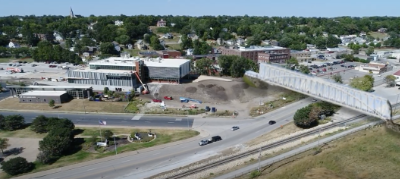
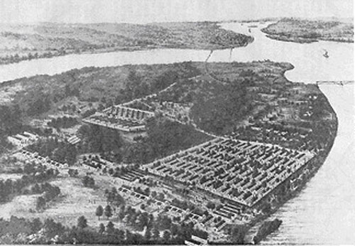
Check out a birds-eye view of the pedestrian First Bridge project, connecting our downtown to the Mississippi River Trail.
A Pictoral History of the First Railroad Bridge Across the Mississippi River and Its Three Successors.
by Curtis C. Roseman (1941-2020)
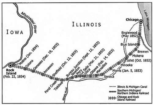
When the Chicago and Rock Island Railroad was completed in 1854 under the direction of Henry Farnam and his partner Joseph Sheffield, it became the first to connect the East with the Mississippi River. This map shows the completion dates at various points along the route westward from Chicago. One of the reasons this route was chosen was the relative ease with which the Mississippi could be bridged at Rock Island. This reach of the Mississippi River, the location of the Rock Island Rapids, is geologically youthful. Its narrow channel with a limestone island (Rock Island) could be used as a stepping-stone for the bridge. (Map drawn by the Cartography class at Augustana College, Spring 2003, under the direction of Kathy Dowd)
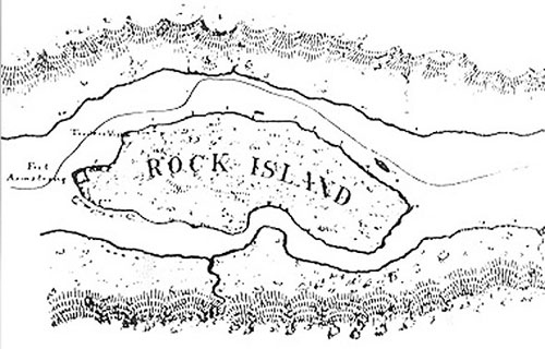
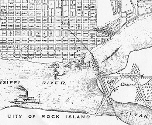
Rock Island in 1829. Here the Mississippi River runs from east to west: Iowa is on the upper part of this map. Soon the Tri Cities (today called the Quad Cities) would surround this island; Davenport, Iowa in the upper left, Rock Island, Illinois in the lower left, and Moline, Illinois in the lower right. In 1816 the U. S. government established Fort Armstrong at the west end of the island. The line through the main channel, north of the island, indicates the trace followed by steamboats through the dangerous Rock Island rapids.
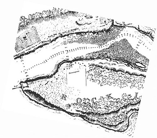
Upstream from Fort Armstrong is a piece of the island that protrudes out into the main channel of the river, labeled "Traders Vista." It is close to the location of a cabin (and later a house that remains today) occupied by George Davenport, who was the Fort's sutler and trader of goods after whom the city was named. Apparently from this spot, Col. Davenport would look up and down stream for potential customers of his trade. Trader's Vista would become the location of the first bridge across the main channel of the river. (Map courtesy of the Rock Island District, U. S. Corps of Engineers)
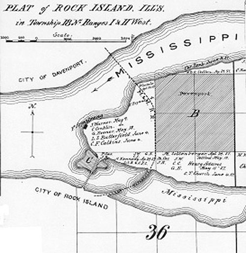
This map of the western part of the island is from a survey of the Rock Island Rapids conducted by Robert E. Lee in 1837. Although it had been deactivated by this time, Fort Armstrong is shown at the western tip of the island. Col. Davenport's land is shown in the center of the image near Trader's Vista. In the northwest (upper left) corner in Davenport is land and a house occupied by Antoine LeClaire, who donated that land for the beginnings of the first railroad in Iowa, the Mississippi and Missouri, which had corporate links to the Rock Island Railroad and to the Bridge Company.
LeClaire's house would become the first railroad depot in Iowa. The first train on the Mississippi and Missouri left this depot in August 1855, destined for Walcott, eight months before the bridge connected Iowa with Illinois. Then in December 1855 (11:59 p.m., December 31st, to be exact) the first train reached Iowa City, some fifty miles west of Davenport. The Mississippi and Missouri Railroad, finally reached Council Bluffs, Iowa on the Missouri River in 1869, by that time having become part of the Chicago, Rock Island, and Pacific Railroad. (Map courtesy of the Rock Island District, U. S. Corps of Engineers)
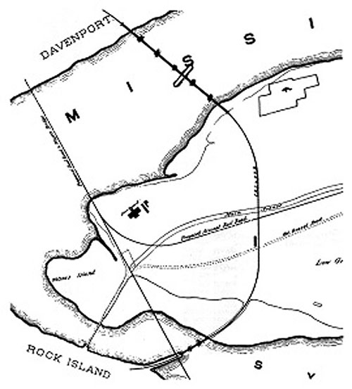
This 1857 map shows the circular path of the new railroad across Rock Island, and the position of the new bridge at Traders Vista. Trains would head eastward out of the City of Rock Island, then turn north on the island, and then enter the City of Davenport from the southeast. Also shown here is the large tract held by Col. Davenport. (Map from Flagler, 1877)
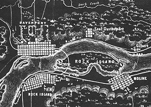
This 1860s map places the first bridge in the context of the Tri Cities. The Rock Island Railroad had come from the east though Moline to the City of Rock Island. The Mississippi and Missouri headed northwest out of Davenport. The town of Gilbert, in the upper right, would become Bettendorf in 1903. (Map courtesy of the Rock Island County Historical Society, Moline, Illinois)
The First Bridge, 1856-1866
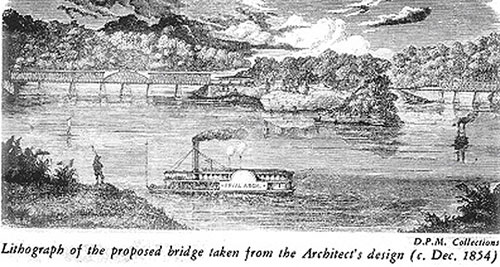
This December 1854 view from downstream, drawn some sixteen months before the bridge was completed in April 1856, shows how the bridge utilized Rock Island as a stepping-stone. On the left are the six spans of the bridge across the main channel of the Mississippi River extending from the island to Iowa. On the right are three spans of the bridge over the Slough between the island and the City of Rock Island on the Illinois shore. (Image courtesy of the Putnam Museum, Davenport, Iowa)
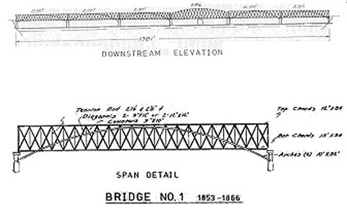
The first bridge was completed on April 21, 1856. The Howe Truss design of the bridge was distinguished by long wooden arches, anchored to the piers on either side of each fixed span. (Diagram from Riebe, 1982. Courtesy of the Rock Island Arsenal Museum)
This artist's rendition of the first bridge is fairly faithful to its design. The bridge was made primarily of wood and had five fixed spans, each with a flat top and each 250 feet long. The draw, or swing, span was 286 feet long and located near the middle of the river. At the time it was the longest swing span in the world.
This view from downstream shows Ft. Armstrong at the west end of the island. The house in the painting is presumed to be the Davenport House, although in actuality it was located east of the bridge and would not be visible in this view. (Painting from Nevins, 1922)
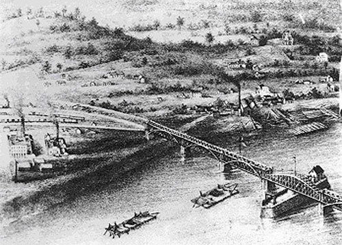
This bird's eye view shows the first bridge approaching the Iowa side of the river. On the right is the bridge superintendent’s house perched on the center pier of the draw span. In the upper left is a rail yard located on land that was donated to the railroad by Antoine LeClaire. His house on that land was used as the first railroad depot in Iowa. The Mississippi and Missouri Railroad was completed from Davenport to Iowa City on December 31, 1855, some four months before the bridge was finished. (Image courtesy of the Putnam Museum, Davenport, Iowa)
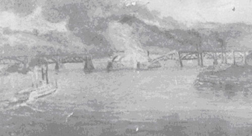
On the morning of May 6, 1856, just two weeks after the bridge opened, the steamboat Effie Afton crashed into the bridge, causing one span of the bridge and the boat to burn. In a series of court cases, steamboat interests claimed that the bridge was an impediment to navigation. In the most famous of these cases, Hurd et al. v. the Rock Island Railroad, Abraham Lincoln defended the railroad in September 1857. It concluded with a hung jury, allowing the railroad to continue using the bridge. (Image from Slattery, 1988. Courtesy of the Rock Island County Historical Society, Moline, Illinois)
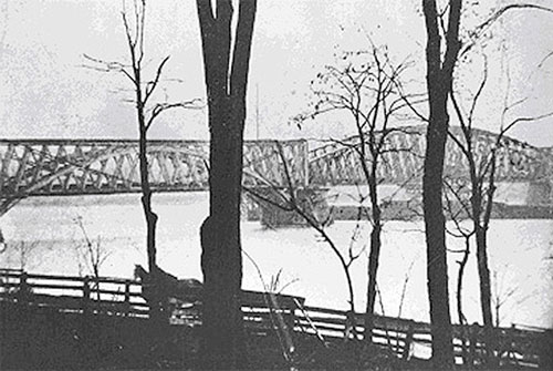
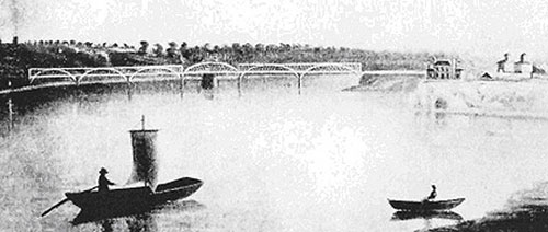
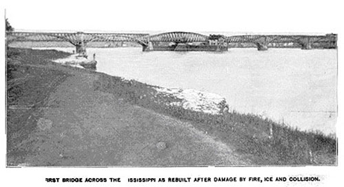
Four months passed before the bridge was fully repaired after the Effie Afton damaged it in May 1856. This photograph, taken from a point upstream near the Davenport House on the island, is one of only two photos of the first bridge that we have found thus far. It was probably taken around 1860. (Photo courtesy of the Putnam Museum, Davenport, Iowa)
Here is the other photo. This is taken in 1860 from east of the Davenport House. Both photos show some new V-shaped cables that were added to the fixed spans, sometime after the Effie Afton incident, to supply additional support to the bridge. (Photo courtesy of the Rock Island District, U. S. Corps of Engineers)
This 1863 panoramic map, facing southwest, shows the Civil War prison camp that had been established on the island in that year. The prison held a total of about 13,000 Confederate prisoners during the year and a half it was open. In the upper right corner you can see the first bridge extending over the main channel of the river from Traders Vista to Davenport. In the upper center of the image are a wagon bridge and the railroad bridge extending over the Slough to the City of Rock Island. (Image from: A History of Rock Island and Rock Island Arsenal... no date)
The Second Bridge 1866-1872
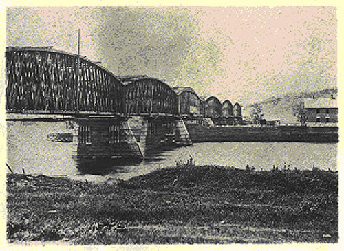
The second bridge was built in 1866 on the same piers as the first, with minimal disruption to rail service during the construction period. Like the first bridge it was made of wood trusses; unlike the first, each span had a curved top. This view from the island shows that the piers were slanted and pointed on their upstream sides to minimize damage from ice, debris, or boats that might strike them. The bridge superintendent’s house can be seen on the right at the upstream end of the pier that supported the draw span. (Photo courtesy of the Putnam Museum, Davenport, Iowa)
The second bridge viewed from the bluff in East Davenport, with the island and the bluffs on the Illinois side in the background. (Photo Courtesy of the Putnam Museum, Davenport, Iowa)
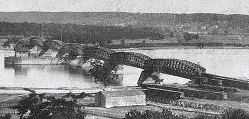
In 1868 a tornado severely damaged the second bridge, shown in this view from Davenport. Because the stone piers of these first two bridges were not well anchored to the rock bed of the river, they slid along the bottom under the pressure of strong winds. (Photo from Nevins, 1922)
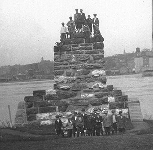
What remained of those piers is shown in this 1915 photo of school children on a field trip to the Island from the Davenport Museum. (Photo courtesy of the Putnam Museum, Davenport, Iowa)
The Third Bridge (Government Bridge) 1872-1896
The curved path of the first rail line across Rock Island and through Traders Vista is shown on this late 1860s map. The straight line across the downstream (west) end of the island shows the path of the railroad and the location of the new, third bridge to be built in 1872. (Map from Slattery, 1988)
This photograph shows the third bridge under construction in 1872. In the foreground is Fort Armstrong Avenue on Rock Island. Because the railroad and the government cooperated in the project, the bridge first became known as the Government Bridge at this time. The same Fort Armstrong Avenue is used today by vehicles approaching the current Government Bridge from the Illinois side. (Photo courtesy of the U. S. Army, Rock Island Arsenal Museum, Rock Island, Illinois.)
The third bridge—here viewed from the island—differed from the first two: it was in a new location, it was a double deck structure made of iron and steel trusses, and its draw span was adjacent to the shore on the Illinois (island) side. The railroad used the upper deck, while wagons, livestock and pedestrians used the lower deck. (Photo courtesy of the U. S. Army, Rock Island Arsenal Museum, Rock Island, Illinois.)
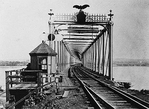
A view of the upper, railroad, deck from Davenport, with eagle adorning the entrance. (Photo courtesy of the U. S. Army, Rock Island Arsenal Museum, Rock Island, Illinois.)
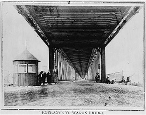
View of the lower, wagon, deck from Davenport. (Photo courtesy of the U. S. Army, Rock Island Arsenal Museum, Rock Island, Illinois.)
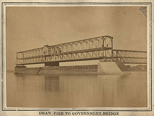
Here is a photograph of the swing span of the third bridge in its open position, taken from the island upstream from the bridge. This span was 366 feet in length and located adjacent to the Rock Island shore. (Photo courtesy of the Putnam Museum, Davenport, Iowa)
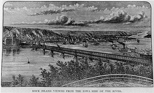
View of the third bridge from East Davenport with City of Rock Island in the background. Visible is the first Arsenal building on the island, today called the “Clock Tower Building” and headquarters of the Rock Island District of the U. S. Corps of Engineers. (Print from: Rock Island Illustrated, Comp. by W. P Quayle and H. P. Simpson. Rock Island, IL: Daily Argus Print, 1888, page 95. Photo used courtesy of the U. S. Army, Rock Island Arsenal Museum, Rock Island, Illinois)
This 1870s map shows the third bridge cutting across the west end of the Island. The second bridge is gone, but remnants of the rail lines that approached it on the Iowa side are visible, across the main channel of the river from Trader's Vista on Rock Island. (Map from: A. T. Andreas, Illustrated Historical Atlas of the State of Iowa, 1875. Chicago: Andreas Atlas Co.)
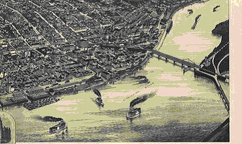
This 1888 panoramic map shows Davenport and the third bridge. (From the Library of Congress, American Memory project.)
The Current Bridge (Government Bridge) 1896-Present
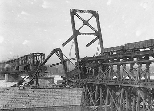
While the draw span of the current Government Bridge was under construction in February 1896, a fierce ice jam caused this damage. (Photo courtesy of the U. S. Army, Rock Island Arsenal Museum, Rock Island, Illinois.)
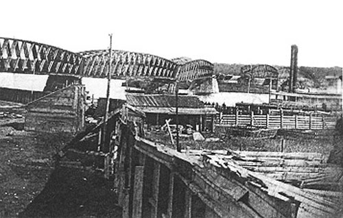
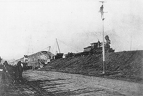
This 1896 view from Davenport shows the draw span (on the right) and one fixed span of the new bridge completed. Old fixed spans of the third bridge are on the left. Shown here is "Traveler" a spider-like construction device that straddled the bridge, moving back and forth to disassemble the old and assemble the new. (Photo courtesy of the U. S. Army, Rock Island Arsenal Museum, Rock Island, Illinois.)
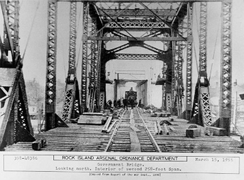
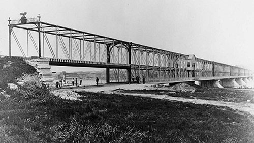
This 1896 interior view shows the new Government Bridge under construction; the new bridge in the foreground and the old in the background. The new bridge was set on the same piers as the third, but was made wider to accommodate a double railroad track.(Photo courtesy of the U. S. Army, Rock Island Arsenal Museum, Rock Island, Illinois.)
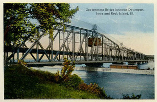
The fourth bridge, our current Government Bridge, was completed in December 1896. Like the third bridge, its draw span was located adjacent to the island.
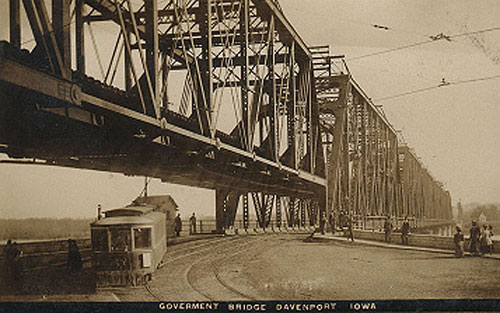
Beginning in the 1880s the third bridge had accommodated horse-drawn trolley cars, and in 1894 the electric trolley. The fourth, current bridge continued that tradition until 1940 when the bridge line was discontinued. All other trolley lines in the Quad Cities had been discontinued in 1936. (Photo courtesy of the Putnam Museum, Davenport, Iowa)
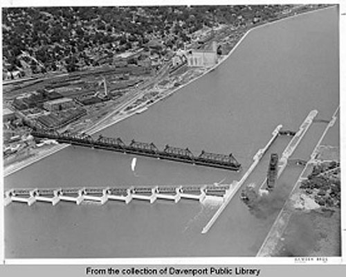
Locks and Dam No. 15 were completed in the spring of 1934 at the site of the Government Bridge. At the top of this aerial photo you can see crescent-shaped rail yards following the path that led to the first and second bridges. Remnants of those rail lines remain there today. (Photo Courtesy of Davenport Public Library; accessed from the Upper Mississippi Valley Digital Image Archive: http://www.umvphotoarchive.org/)
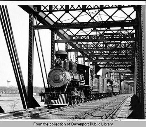
In 1956, a vintage steam train was brought to the Quad Cities to celebrate the 100th anniversary of the completion of the first bridge. Here it is crossing the upper deck of the 1896 Government Bridge with the island in the background. (Photo Courtesy of Davenport Public Library; accessed from the Upper Mississippi Valley Digital Image Archive: http://www.umvphotoarchive.org/)
Background, Acknowledgements, and Bibliography
This web page is an expansion of a presentation prepared and presented by Curtis C. Roseman to the 3rd Annual Henry Farnam Dinner, held on Feb. 22, 2006 in Davenport, Iowa. The dinner is organized by the Quad Cities Henry Farnam Committee, an independent group of volunteers and representatives of local organizations. The committee is affiliated with River Action Inc., a regular contributing sponsor of the dinner. Questions and comments should be directed to kwine@riveraction.org.
Images on this web page were obtained through the cooperation of several libraries and museums, which are named in the credits for each image. We appreciate their cooperation. I also want to thank the numerous individuals who contributed to this project. Kris Leinicke of the Rock Island Arsenal Museum, Joe Nobiling of the U. S. Army, Corps of Engineers, and Eunice Schlichting of the Putnam Museum provided valuable assistance in accessing images. Elizabeth Roseman contributed to the substance of the text and helped make it readable, and Jesse Inskeep assisted in putting together the web page.
Selected Bibliography:
Sources of information on and images of the railroad bridges at Rock Island are widely scattered. Among the basic sources that were helpful to this project are these:
- Agnew, Dwight L. "Jefferson Davis and the Rock Island Bridge," Iowa Journal of History, Vol. 47, No. 1, January 1949.
- Flagler, Daniel W. A history of the Rock Island arsenal from its establishment in 1836 to December 1876 and of the Island of Rock Island, the site of the arsenal, from 1804 to 1863. Washington: USGPO, 1877. (also known as Ordnance Memorandum #20)
- Fowle, Frank F., "A Famous Interference Case: Lincoln and the Bridge." National Electric Light Association Bulletin, Volume XIV, No. 10, October 1927, pp. 613-622.
- Fowle, Frank F., "The Original Rock Island Bridge Across The Mississippi River." The Railway & Locomotive Historical Society, Bulletin No. 56, 1941, pp. 4-15.
- Neubauer, James A. "Moonlight Over the Mississippi: Celebrating the Sesquicentennial of the First Railroad Crossing of the Mississippi River." Remember the Rock, Vol. 3, No. 1, Spring 2006, pp. 28-36.
- Nevins, F. J. "Seventy Years of Service: From Grant to Gorman", Rock Island Magazine, Seventieth Anniversary, October, 1922.
- Nothstein, Ira O. "The First Railroad Bridge to Cross the Mississippi," Museum Quarterly, Vol. 1, No. 2, April 1956.
- Riebe, William. "The Government Bridge," The Rock Island Digest, Vol. 2, (1982), pp. 68-79.
- Slattery, Thomas J. An Illustrated History of the Rock Island Arsenal and Arsenal Island. Rock Island, Ill.: Historical Office, U. S. Army Armament, Munitions and Chemical Command. Part I (1988) and Part II (1989)
- U. S. Army Rock Island Arsenal. A History of Rock Island and Rock Island Arsenal From Earliest Times to 1954. Vol. I to 1898. no date, Rock Island, Ill.

